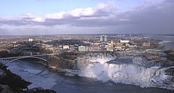
Niagara Falls, NY
Niagara Falls (Niagara Falls) is a city in Niagara County, New York, the United States. According to the 2010 census, the population of the city was 50,193, down about 10% from the previous 2000 census. Across the Niagara River, on the other side is Niagara Falls in Canada and Ontario, both named after the Niagara Falls. It belongs to the Buffalo-Niagara Falls metropolitan area
| Niagara Falls City of Niagara Falls | |
|---|---|
 Niagara Falls | |
| Position | |
 Top: Niagara County in New York State Bottom: Position in Niagara County | |
| Position | |
Niagara Falls, NY (USA) Niagara Falls, NY (NY) | |
| Coordinates: 43 degrees 05 minutes 39 seconds north latitude 79 degrees 01 minutes 02 seconds west longitude / 43.09417 degrees north latitude 79.01722 degrees west longitude / 43.09417 degrees west longitude -79.01722 | |
| administration | |
| country | |
| State | |
| county | Niagara County |
| city | Niagara Falls |
| mayor | Paul Dyster (Democratic Party) |
| geography | |
| area | |
| City | 43.5 km2 (16.8 mi2) |
| land | 36.4 km2 (14.1 mi2) |
| water surface | 7.1 km2 (2.8 mi2) |
| water area ratio | 16.37% |
| Elevation | 187 m (614 ft) |
| population | |
| population | (as of 2010) |
| City | 50,193 |
| population density | 1,527.3 people/km2 (3,955.7 people/mi2) |
| urban area | 976703 |
| urban area | 1254066 |
| Other | |
| equal time | Eastern Standard Time (EST) (UTC-5) |
| daylight saving time | Eastern Daylight Time (EDT) (UTC-4) |
| ZIP code | 14301-14305 |
| area code | 716 |
History
The city of Niagara Falls was established on March 17, 1892. Governor Rosewell L. Flower signed a law to promote the city. Thomas Vincent WELCH, a member of the Imperial Sanction Committee and a member of the New York State Council, and more importantly, a second-generation Irish American, was in charge of the bill's signature and having Governor Flower sign St. Patrick's Day. Historically, the city of Niagara Falls was built around a factory that turns the energy that falls into electricity. The central town now surrounds the Niagara Falls State Park where you can see the American, Canadian and Bridal Bale falls nearby. The European immigrants to this area were first by missionaries and explorers in the 17th century. The influx of the newcomers turned the hostile indigenous peoples into fighting in the competition for fur trade.
By the end of the 19th century, the city of Niagara Falls had become a heavy industrial zone due to the huge power provided by the rapids of the Niagara River. The town has a relatively strong industrial base even today, but it is away from places where tourists visit.
The neighboring Love Canal, where U.S. President Jimmy Carter declared an emergency there in 1978, attracted the attention of the national media when hundreds of residents moved there. Starting in 1920, the area was developed as a residential area after being used as a landfill for chemical industrial waste (later toxic industrial waste). The Super Fund Law was enacted in 1980 to protect local residents, families and communities from being seriously contaminated with toxic substances, in response to the situation at the Love Canal.
The city of Niagara Falls in Ontario, the twin city of Canada, gained a lot of power in the tourism industry in the 1990s and was called Las Vegas, Canada, with casinos and high rise hotels allowed, while the city of Niagara Falls in New York State remains more natural and unenterprising. However, in 2004, the Seneca people of Indigenous Peoples established Seneca Niagara and Casino in the former Niagara Falls Conference Civic Hall, which established the independent territory of Indigenous peoples in the center of the city.
Economy
The economy of Niagara Falls was originally based on power generated by the water fall itself or at least a large amount of falling water. This cheap and abundant energy source was the driving force behind the rapid rise of the industrial zone. At the end of the 19th century, many immigrants from European countries such as Italy and Poland moved to work in the chemical, steel and other manufacturing plants owned by Occidental companies in the region.
The importance of Niagara Falls was reduced for several reasons in the late 20th century. Perhaps the most significant was the high wages of blue collar workers, the strength of the union, and the high taxes compared to corrupt governments and other parts of the United States. Previously, inexpensive products made at Niagara Falls were produced more cheaply elsewhere. Another major reason was the movement to the suburbs, which were the national phenomenon at that time. The city had a population of over 100,000 people at most, but as factories were closed and people moved to the south and west to find jobs, the population was nearly halved.
However, a new era of economic prosperity is slowly coming to pass for Niagara Falls and the rest of Niagara County. Local and state governments have begun to make use of the physical and cultural advantages that the Niagara region originally has. the Niagara Valley, the burgeoning wine road, the historical landscape, and of course the Niagara Falls itself. Moving away from the past industries of the town to an economy based on a more sustainable tourism industry has been reviving the city in recent years. Later in 2001, New York State has launched the state's economic development organization, USA Niagara Development Corporation, focusing specifically on promoting the development of the City center of Niagaa Falls.
The current development strategy of the Niagaa Falls focuses on practical ways, such as a promotional project that will attract attention with actual economic effects, to revitalize the vacant central town or underutilized buildings. The new Niagaa Falls Conference Center opened in 2005, the redeveloped United Office Building, the new Mist Theater, the former Holiday in Select, the new Crowne Plaza Resort with several restaurants including Starbucks Coffee, the Niagara Air Museum and the planned Niagara Experience Center in the city, and of course, the Seneca Niagara Falls are repositioned at major destinations.
The Niagara Falls is believed to be one of the top 10 tourist spots in the United States, with 8 to 10 million visitors a year.
geography
The city of Niagara Falls is located at latitude 43 degrees 5 minutes 39 seconds north and longitude 79 degrees 1 minutes 2 seconds west and latitude 43.09417 degrees north and longitude 79.01722 degrees west and 43.09417 degrees west; -79.01722.
It also borders the United States and Canada.
According to the United States Statistical Bureau, the Niagara Falls area is 43.5km² (16.8 mi²). 36.4km² (14.1mi²) is land and 7.1km² (2.8mi²) is water area. The area accounts for 16.37% of the total area.
demographic dynamics

The following is demographic data from the 2000 census.
fundamental data
- Population: 55,593
- Number of households: 24,099 households
- Number of Families: 14,266 families
- Population density: 1,527.7 people/km2 (3,955.7 people/mi2)
- Number of Homes: 27,837 houses
- Residential density: 765.0 units/km2 (1,980.7 units/mi2)
population structure
- White: 76.21%
- African American: 18.72%
- Native American: 1.64%
- Asians: 0.71%
- Pacific Islands: 0.05%
- Other races: 0.68%
- Mixed: 1.99%
- Hispanic Latino: 2.00%
demographic structure
- Under 18: 24.7%
- 18-24 years old: 8.6%
- 25-44 years old: 27.7%
- 45-64 years old: 20.5%
- Over 65 years of age: 18.6%
- Median Age: 38 years old
- Sex ratio (male population per 100 women)
- Total population: 87.9
- Over 18 years of age: 83.0
Households and family (number of households)
- We have children under 18: 27.8%
- Married and living together: 36.2%
- Single, divorced, and deceased women are householders: 18.3%
- Non-family: 40.8%
- Single Family: 35.9%
- Elderly people aged 65 and older live alone: 15.2%
- average number of constituent members
- Households: 2.27 people
- Family: 2.96
income and family
- median income
- Households: $26,800
- Family: 34,377 US dollars
- gender
- Male: 31,672 US dollars
- Female: 22,124 US dollars
community
In Niagara Falls, two newspapers are published, a weekly "Niagara Falls Reporter" and a daily "Niagara Gazette."
traffic
railroad
It's in Amtrak's Niagara Falls (New York State) station 825 Depot Avenue.
The trains that stop at Niagara Falls in Amtrak station in New York are as follows:
- The Mapleleaf, a daytime international train between Toronto and New York...one round trip a day
- Mid-day, mid-flight Empire Service...Two round-trip services a day (buses running to the Niagara Falls (New York State) arrive at and depart from this station)
Bus
- The route bus is operated by the Niagara Frontier Transportation Bureau.
education
Residents are incorporated into the Niagara Falls City School District. Lassar High School was closed in the late 1990s and a new Niagara Falls High School was opened. The new high school is a combination of Lassar High School and former Niagara Falls High School. The former Niagara Falls High School building on Pine Avenue and Portage Road became the Center for Art and Culture.
Niagara University is also near.
Past, Present Well Known Residents
- Rashad Evans, mixed martial artist
- Thomas Aquinas Daily, Landscape and Still Life Painter
- Lee Haira, composer
- Anthony Rotempio, Singer, Actor
- Sal Magley, Baseball players
- Rick Manning, Baseball Player
- Mark Mello, Professional Wrestler
- Tom Roteria, jazz guitarist
- April Stevens, singer
- Tommy Tedesco, the most recorded jazz guitarist
- Franchit Tone, Actor
Footnotes
- ^ American FactFinder. U.S. Census Bureau. February 4, 2011. Read April 5, 2011
- ^ "Love Canal Collection". University of Buffalo Libraries. Read on February 3, 2007.
- ^ Niagara Falls, NY. Amtrak. Read July 3, 2016
- ^ Maple Leaf. P2. Amtrak. April 24, 2016. June 27, 2016 (PDF file)
- ^ Empire Service. P2. Amtrak. April 24, 2016. June 27, 2016 (PDF file)
- ^ Niagara Frontier Transportation Authority. NFTA. Read July 3, 2016
See also
- Niagara Falls
- Niagara Falls, Ontario (Canada)
external link
- Niagara Falls Reporter Newspaper site
- Niagara Gazette Newspaper site
- City of Niagara Falls Official site
- Niagara USA tourism site
- USA Niagara Development Corp. site
- NiagaraDowntown virtual tour site
- "What has Niagara Falls?" ~ Frank Parlato Jr. Now-classic essay on the many wonders, marvels and sights to see along the Niagara; originally published in the Niagara Falls Reporter.
- "Trusellos Bakery"